
Carte topographique Simpsonville
Carte interactive
Cliquez sur la carte pour afficher l’altitude.
À propos de cette carte
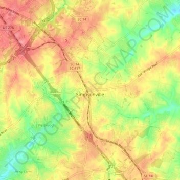
Nom : Carte topographique Simpsonville, altitude, relief.
Altitude moyenne : 258 m
Altitude minimum : 215 m
Altitude maximum : 292 m
Simpsonville is located in southeastern Greenville County at 34°44′0″N 82°15′36″W / 34.73333°N 82.26000°W / 34.73333; -82.26000 (34.733375, -82.260001), between Mauldin to the northwest and Fountain Inn to the southeast. The center of town has an elevation of 866 feet (264 m) above sea level.