
Carte topographique Mount Hagen
Carte interactive
Cliquez sur la carte pour afficher l’altitude.
À propos de cette carte
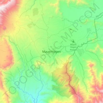
Nom : Carte topographique Mount Hagen, altitude, relief.
Altitude moyenne : 1 904 m
Altitude minimum : 1 220 m
Altitude maximum : 3 542 m
Mount Hagen (Tok Pisin: Maun Hagen) is the third largest city in Papua New Guinea, with a population of 46,250. It is the capital of the Western Highlands Province and is located in the large fertile Wahgi Valley in central mainland Papua New Guinea, at an elevation of 1,677 m (5,502 ft).