
Carte topographique Achankovil
Carte interactive
Cliquez sur la carte pour afficher l’altitude.
À propos de cette carte
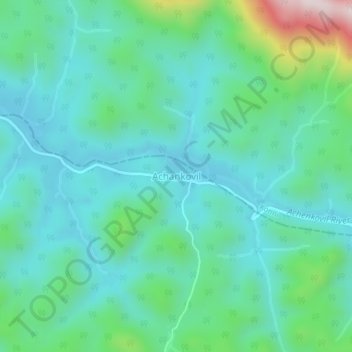
Nom : Carte topographique Achankovil, altitude, relief.
Lieu : Achankovil, Punalur, Kollam District, Kerala, India (9.07224 77.10168 9.11224 77.14168)
Altitude moyenne : 177 m
Altitude minimum : 54 m
Altitude maximum : 638 m
Autres cartes topographiques
Cliquez sur une carte pour visualiser sa topographie, son altitude et son relief.
Kulathupuzha
Kulathupuzha, Punalur, Kollam District, Kerala, 691310, India
Altitude moyenne : 150 m
Thenmala Dam
India > Kerala > Punalur > Thenmala
Thenmala Dam, Thenmala, Punalur, Kollam, Kerala, India
Altitude moyenne : 155 m
Vellor Ela Thodu
Vellor Ela Thodu, Punalur, Kollam, Kerala, 691548, India
Altitude moyenne : 77 m
Kulathupuzha
Kulathupuzha, Punalur, Kollam, Kerala, 691310, India
Altitude moyenne : 226 m
Shendurney WLS
India > Kerala > Punalur > Thenmala
Shendurney WLS, Thenmala, Punalur, Kollam, Kerala, India
Altitude moyenne : 367 m