
Carte topographique North Richland Hills
Carte interactive
Cliquez sur la carte pour afficher l’altitude.
À propos de cette carte
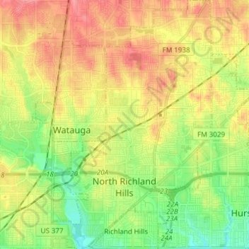
Nom : Carte topographique North Richland Hills, altitude, relief.
Lieu : North Richland Hills, Tarrant County, Texas, United States (32.80874 -97.26452 32.91152 -97.18592)
Altitude moyenne : 191 m
Altitude minimum : 154 m
Altitude maximum : 230 m
Autres cartes topographiques
Cliquez sur une carte pour visualiser sa topographie, son altitude et son relief.
USA
United States > Texas > Tarrant County > Arlington
USA, Arlington, Tarrant County, Texas, 76011, United States
Altitude moyenne : 170 m
Boomtown
United States > Texas > Tarrant County > Arlington
Boomtown, Arlington, Tarrant County, Texas, 76006, United States
Altitude moyenne : 170 m
Luther Lake
United States > Texas > Tarrant County > Fort Worth
Luther Lake, Fort Worth, Tarrant County, Texas, United States
Altitude moyenne : 212 m
Southwind
United States > Texas > Tarrant County > Arlington
Southwind, Arlington, Tarrant County, Texas, 76002, United States
Altitude moyenne : 175 m
White Settlement
United States > Texas > Tarrant County
White Settlement, Tarrant County, Texas, United States
Altitude moyenne : 211 m
Forest Hill
United States > Texas > Tarrant County
Forest Hill, Tarrant County, Texas, United States
Altitude moyenne : 198 m
Azle
United States > Texas > Tarrant County
Azle, Tarrant County, Texas, 76020, United States
Altitude moyenne : 223 m
Fort Worth
United States > Texas > Tarrant County > Fort Worth
Fort Worth, Tarrant County, Texas, 76102, United States
Altitude moyenne : 202 m