
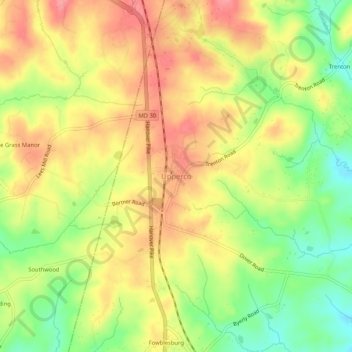
Carte topographique Upperco
Carte interactive
Cliquez sur la carte pour afficher l’altitude.
À propos de cette carte
Nom : Carte topographique Upperco, altitude, relief.
Lieu : Upperco, Baltimore County, Maryland, 21155, United States (39.54292 -76.85598 39.58292 -76.81598)
Altitude moyenne : 218 m
Altitude minimum : 169 m
Altitude maximum : 258 m
Autres cartes topographiques
Cliquez sur une carte pour visualiser sa topographie, son altitude et son relief.
Linden Springs
United States > Maryland > Baltimore County
Linden Springs, Baltimore County, Maryland, 21053, United States
Altitude moyenne : 253 m
Treetops
United States > Maryland > Baltimore County
Treetops, Baltimore County, Maryland, United States
Altitude moyenne : 131 m
Parkville
United States > Maryland > Baltimore County
Parkville, Baltimore County, Maryland, 21234, United States
Altitude moyenne : 91 m
Reisterstown
United States > Maryland > Baltimore County > Reisterstown
Reisterstown, Baltimore County, Maryland, 21136, United States
Altitude moyenne : 199 m
Pikesville
United States > Maryland > Baltimore County > Pikesville
Pikesville, Baltimore County, Maryland, United States
Altitude moyenne : 135 m
Middle River
United States > Maryland > Baltimore County > Middle River
Middle River, Baltimore County, Maryland, 21220, United States
Altitude moyenne : 13 m
White Marsh
United States > Maryland > Baltimore County > White Marsh
White Marsh, Baltimore County, Maryland, United States
Altitude moyenne : 39 m
Rosedale
United States > Maryland > Baltimore County > Rosedale
Rosedale, Baltimore County, Maryland, 21237, United States
Altitude moyenne : 28 m
Owings Mills
United States > Maryland > Baltimore County > Owings Mills
Owings Mills, Baltimore County, Maryland, 21117, United States
Altitude moyenne : 173 m
Dundalk
United States > Maryland > Baltimore County > Dundalk
Dundalk, Baltimore County, Maryland, 21222, United States
Altitude moyenne : 6 m
Jacksonville
United States > Maryland > Baltimore County > Jacksonville
Jacksonville, Baltimore County, Maryland, 21131, United States
Altitude moyenne : 170 m
Long Green
United States > Maryland > Baltimore County > Towson > Long Green
Long Green, Towson, Baltimore County, Maryland, 21057, United States
Altitude moyenne : 129 m
Catonsville
United States > Maryland > Baltimore County > Catonsville
Catonsville, Baltimore County, Maryland, United States
Altitude moyenne : 105 m
Towson
United States > Maryland > Baltimore County > Towson
Towson, Baltimore County, Maryland, United States
Altitude moyenne : 114 m
Parkville
United States > Maryland > Baltimore County > Parkville
Parkville, Baltimore County, Maryland, 21234, United States
Altitude moyenne : 111 m
Towson
United States > Maryland > Baltimore County
Towson, Baltimore County, Maryland, 21252, United States
Altitude moyenne : 101 m
Cockeysville
United States > Maryland > Baltimore County
Cockeysville, Baltimore County, Maryland, 21031, United States
Altitude moyenne : 131 m