
Carte topographique Stakčín
Carte interactive
Cliquez sur la carte pour afficher l’altitude.
Stakčín
The municipality lies in the Cirocha river valley, at an altitude of 257 metres and with a total area of 167.742 km2. According to the 2013 census it had a population of 2452 inhabitants. It lies between the Vihorlat and Bukovské vrchy mountains. The municipality is the seat of the Poloniny National Park governing body.
À propos de cette carte
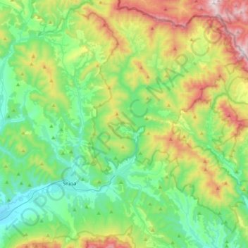
Nom : Carte topographique Stakčín, altitude, relief.
Altitude moyenne : 471 m
Altitude minimum : 181 m
Altitude maximum : 1 147 m