
Faire un don
Équipez-vous pour votre prochaine aventure :
En tant que Partenaire Amazon, ce site perçoit une commission sur les achats éligibles sans surcoût pour vous.
Carte topographique Banggi Island
Cliquez sur la carte pour afficher l’altitude.
Faire un don
Équipez-vous pour votre prochaine aventure :
En tant que Partenaire Amazon, ce site perçoit une commission sur les achats éligibles sans surcoût pour vous.
Banggi Island
Banggi Island (Malay: Pulau Banggi) is located within the Kudat Division of Sabah in Malaysia. With an area of 440.7 square kilometres, it is the largest island in Malaysia followed by Bruit Island, Langkawi Island and Penang Island. It is located off the northern coast of Sabah near Marudu Bay. The highest elevation on the island is Bukit Sinambung with height of 529 metres. As of 2016, it has an estimated population of 30,000. Banggi's largest settlement is Limbuak. In 2014, a new township was proposed to be built in the island. The island is also part of the gazetted area of Tun Mustapha Marine Park.
Faire un don
Équipez-vous pour votre prochaine aventure :
En tant que Partenaire Amazon, ce site perçoit une commission sur les achats éligibles sans surcoût pour vous.
À propos de cette carte
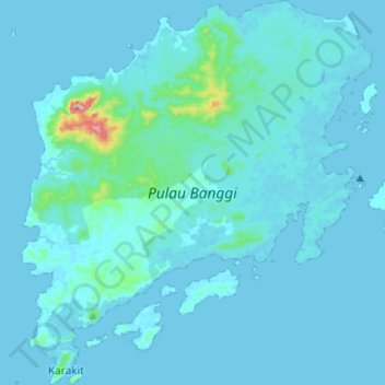
Nom : Carte topographique Banggi Island, altitude, relief.
Lieu : Banggi Island, Kudat, Kudat Division, Sabah, Malaysia (7.10037 117.05402 7.36281 117.29496)
Altitude moyenne : 21 m
Altitude minimum : 0 m
Altitude maximum : 487 m
Faire un don
Équipez-vous pour votre prochaine aventure :
En tant que Partenaire Amazon, ce site perçoit une commission sur les achats éligibles sans surcoût pour vous.
Autres cartes topographiques
Cliquez sur une carte pour visualiser sa topographie, son altitude et son relief.