
Carte topographique Schmidmühlen
Carte interactive
Cliquez sur la carte pour afficher l’altitude.
À propos de cette carte
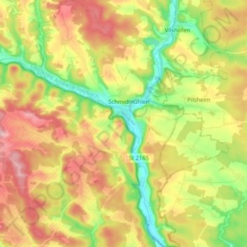
Nom : Carte topographique Schmidmühlen, altitude, relief.
Altitude moyenne : 431 m
Altitude minimum : 347 m
Altitude maximum : 518 m
Autres cartes topographiques
Cliquez sur une carte pour visualiser sa topographie, son altitude et son relief.
Schnaittenbach
Germany > Bavaria > Landkreis Amberg-Sulzbach
Schnaittenbach, Landkreis Amberg-Sulzbach, Bavaria, 92253, Germany
Altitude moyenne : 480 m
Pursruck
Germany > Bavaria > Landkreis Amberg-Sulzbach
Pursruck, Freudenberg, Landkreis Amberg-Sulzbach, Bavaria, 92272, Germany
Altitude moyenne : 496 m
Schmelzmühle
Germany > Bavaria > Landkreis Amberg-Sulzbach > Freihung
Schmelzmühle, Freihung, Landkreis Amberg-Sulzbach, Bavaria, 92271, Germany
Altitude moyenne : 427 m
Bergstein
Germany > Bavaria > Landkreis Amberg-Sulzbach > Illschwang
Bergstein, Illschwang, Illschwang (VGem), Landkreis Amberg-Sulzbach, Bavaria, 92278, Germany
Altitude moyenne : 548 m
Vilseck
Germany > Bavaria > Landkreis Amberg-Sulzbach
Vilseck, Landkreis Amberg-Sulzbach, Bavaria, 92249, Germany
Altitude moyenne : 443 m