
Carte topographique Belmont
Carte interactive
Cliquez sur la carte pour afficher l’altitude.
À propos de cette carte
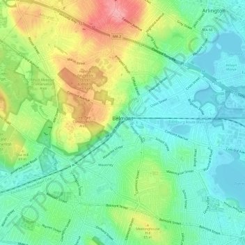
Nom : Carte topographique Belmont, altitude, relief.
Lieu : Belmont, Middlesex County, Massachusetts, United States (42.37506 -71.21195 42.41532 -71.15224)
Altitude moyenne : 40 m
Altitude minimum : -1 m
Altitude maximum : 115 m
Belmont has been referred to as a "Mormon enclave" due to the location of the Boston Massachusetts Temple of the LDS Church at the highest elevation in the town. The prominent gold statue of the Angel Moroni atop the Temple was originally designed by Cyrus Dallin in nearby Arlington, Massachusetts.