Géolocaliser
👉 Easily get elevation data in JSON, GeoTIFF and KML formats using Elevation API
Merci de soutenir ce site ❤️
Faire un don
🎯 Votre prochain emploi est peut-être à un message près : emploichat.fr

Carte topographique Bisley

Cliquez sur la carte pour afficher l’altitude.

👉 Easily get elevation data in JSON, GeoTIFF and KML formats using Elevation API
Merci de soutenir ce site ❤️
Faire un don
🎯 Votre prochain emploi est peut-être à un message près : emploichat.fr

À propos de cette carte

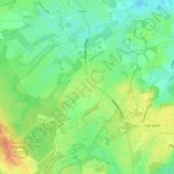
Nom : Carte topographique Bisley, altitude, relief.

Lieu : Bisley, Surrey Heath, Surrey, England, United Kingdom (51.31188 -0.65901 51.33594 -0.61339)

Altitude moyenne : 46 m

Altitude minimum : 27 m

Altitude maximum : 70 m

Autres cartes topographiques

Cliquez sur une carte pour visualiser sa topographie, son altitude et son relief.

Camberley

United Kingdom > England > Surrey > Surrey Heath

The Staff College, to the north of Camberley town centre, is part of the Joint Services Command and Staff College, which provides training and education for established officers in the British Armed Forces and civil servants in the Ministry of Defence. The institution has its origins in the Royal Military…

Altitude moyenne : 88 m

Mytchett

United Kingdom > England > Surrey > Surrey Heath

Altitude moyenne : 82 m

Bagshot

United Kingdom > England > Surrey > Surrey Heath

Altitude moyenne : 80 m

Blackdown Hill

United Kingdom > England > Surrey > Surrey Heath

Altitude moyenne : 97 m

Crawley Hill

United Kingdom > England > Surrey > Surrey Heath > Camberley

Altitude moyenne : 91 m

Mimbridge

United Kingdom > England > Surrey > Surrey Heath > Chobham

Altitude moyenne : 26 m

Merci de soutenir ce site ❤️
Faire un don
🎯 Votre prochain emploi est peut-être à un message près : emploichat.fr

Valley End

United Kingdom > England > Surrey > Surrey Heath

Altitude moyenne : 56 m

Frimley

United Kingdom > England > Surrey > Surrey Heath

Altitude moyenne : 82 m

North Bourne

United Kingdom > England > Surrey > Surrey Heath > Chobham

Altitude moyenne : 33 m

Dunstall Green

United Kingdom > England > Surrey > Surrey Heath > Chobham

Altitude moyenne : 33 m

Frimley Green

United Kingdom > England > Surrey > Surrey Heath

Altitude moyenne : 82 m

Stonehill

United Kingdom > England > Surrey > Surrey Heath

Altitude moyenne : 40 m

Stonehill

United Kingdom > England > Surrey > Surrey Heath

Altitude moyenne : 40 m

Frimley

United Kingdom > England > Surrey > Surrey Heath

Altitude moyenne : 82 m

Camberley

United Kingdom > England > Surrey > Surrey Heath

The Staff College, to the north of Camberley town centre, is part of the Joint Services Command and Staff College, which provides training and education for established officers in the British Armed Forces and civil servants in the Ministry of Defence. The institution has its origins in the Royal Military…

Altitude moyenne : 88 m

Bagshot

United Kingdom > England > Surrey > Surrey Heath

Altitude moyenne : 80 m

Équipez-vous pour votre prochaine aventure :

🍴Couverts de Camping - Set de couverts légers et pliables
Montres altimètre - Montres avec altimètre pour mesurer altitude et dénivelé
🧗Accessoires de trekking - Compléments indispensables pour la marche
🗺️Cartes IGN - Cartes IGN officielles pour randonnée et orientation en France
🔥Pierre à Feu (Firesteel) - Allumez un feu dans toutes les conditions météo

En tant que Partenaire Amazon, ce site perçoit une commission sur les achats éligibles sans surcoût pour vous.