
Carte topographique Wheathampstead
Cliquez sur la carte pour afficher l’altitude.
À propos de cette carte
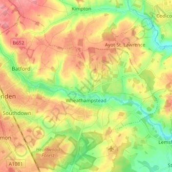
Nom : Carte topographique Wheathampstead, altitude, relief.
Altitude moyenne : 109 m
Altitude minimum : 69 m
Altitude maximum : 147 m
Autres cartes topographiques
Cliquez sur une carte pour visualiser sa topographie, son altitude et son relief.
St Albans
United Kingdom > England > Hertfordshire > St Albans
St Albans was an ancient borough created following the dissolution of the monastery in 1539. It consisted of the ancient parish of St Albans (also known as the Abbey parish) and parts of St Michael and St Peter. The municipal corporation was reformed by the Municipal Corporations Act 1835 and the boundary was…
Altitude moyenne : 100 m
Highfield Park
United Kingdom > England > Hertfordshire > St Albans > Colney Heath
Altitude moyenne : 87 m
Blackmore End
United Kingdom > England > Hertfordshire > St Albans > Wheathampstead
Altitude moyenne : 114 m
Lower Gustard Wood
United Kingdom > England > Hertfordshire > St Albans > Wheathampstead
Altitude moyenne : 112 m
Tyttenhanger
United Kingdom > England > Hertfordshire > St Albans > Colney Heath
Altitude moyenne : 83 m
Napsbury Park
United Kingdom > England > Hertfordshire > St Albans > London Colney
Altitude moyenne : 78 m