
Faire un don
Équipez-vous pour votre prochaine aventure :
En tant que Partenaire Amazon, ce site perçoit une commission sur les achats éligibles sans surcoût pour vous.
Carte topographique Austin
Cliquez sur la carte pour afficher l’altitude.
Faire un don
Équipez-vous pour votre prochaine aventure :
En tant que Partenaire Amazon, ce site perçoit une commission sur les achats éligibles sans surcoût pour vous.
Austin
Austin is an unincorporated small town in, and former county seat of, Lander County, Nevada, United States. In 2020, the census-designated place of Austin had a population of 167. It is located on the western slopes of the Toiyabe Range at an elevation of 6,575 feet (2,004 m). U.S. Route 50 passes through the town.
Faire un don
Équipez-vous pour votre prochaine aventure :
En tant que Partenaire Amazon, ce site perçoit une commission sur les achats éligibles sans surcoût pour vous.
À propos de cette carte
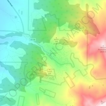
Nom : Carte topographique Austin, altitude, relief.
Lieu : Austin, Lander County, Nevada, United States (39.47299 -117.09145 39.51299 -117.05145)
Altitude moyenne : 2 061 m
Altitude minimum : 1 834 m
Altitude maximum : 2 465 m
Faire un don
Équipez-vous pour votre prochaine aventure :
En tant que Partenaire Amazon, ce site perçoit une commission sur les achats éligibles sans surcoût pour vous.
Autres cartes topographiques
Cliquez sur une carte pour visualiser sa topographie, son altitude et son relief.
Battle Mountain
United States > Nevada > Lander County > Battle Mountain
Battle Mountain's climate is cool semi-arid (Köppen climate classification BSk), receiving just enough precipitation to avoid arid classification. Due to aridity and high elevation, the area commonly experiences large diurnal temperature variation, particularly in summer, when it averages almost 45 °F or 25…
Altitude moyenne : 1 378 m
Battle Mountain
United States > Nevada > Lander County
Battle Mountain's climate is cool semi-arid (Köppen climate classification BSk), receiving just enough precipitation to avoid arid classification. Due to aridity and high elevation, the area commonly experiences large diurnal temperature variation, particularly in summer, when it averages almost 45 °F or 25…
Altitude moyenne : 1 376 m