
Faire un don
Équipez-vous pour votre prochaine aventure :
En tant que Partenaire Amazon, ce site perçoit une commission sur les achats éligibles sans surcoût pour vous.
Carte topographique Middleborough
Cliquez sur la carte pour afficher l’altitude.
Faire un don
Équipez-vous pour votre prochaine aventure :
En tant que Partenaire Amazon, ce site perçoit une commission sur les achats éligibles sans surcoût pour vous.
Middleborough
The nearest regional airports are Taunton Municipal Airport and Plymouth Municipal Airport, the nearest primary commercial airport is New Bedford Regional Airport, and the nearest national and international airports are T. F. Green Airport in Warwick, Rhode Island and Logan International Airport in Boston. From 1954 to 1959, a small runway called North Middleboro Airpark was constructed. It was a 3,000 foot-long paved runway, although it was not depicted in the November 1954 Boston Sectional Chart. Sometime between 1982-1994 it was closed, as it was depicted simply as "Landing Strip" on the 1994 USGS topographic map. A small grassy, unpaved field in South Middleborough is also used for recreational aircraft, but not for transportation.
Faire un don
Équipez-vous pour votre prochaine aventure :
En tant que Partenaire Amazon, ce site perçoit une commission sur les achats éligibles sans surcoût pour vous.
À propos de cette carte
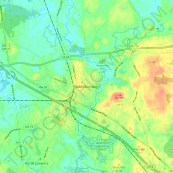
Nom : Carte topographique Middleborough, altitude, relief.
Altitude moyenne : 25 m
Altitude minimum : 4 m
Altitude maximum : 61 m
Faire un don
Équipez-vous pour votre prochaine aventure :
En tant que Partenaire Amazon, ce site perçoit une commission sur les achats éligibles sans surcoût pour vous.