
Carte topographique Matinicus Isle Plantation
Carte interactive
Cliquez sur la carte pour afficher l’altitude.
À propos de cette carte
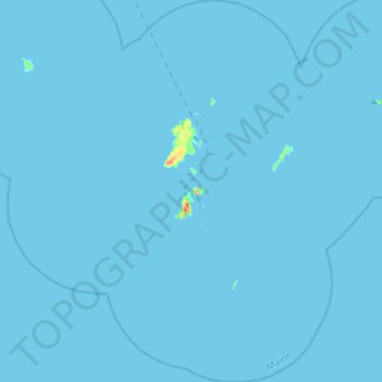
Nom : Carte topographique Matinicus Isle Plantation, altitude, relief.
Altitude moyenne : 0 m
Altitude minimum : 0 m
Altitude maximum : 32 m
Matinicus Isle plantation is an archipelago located on the southeastern fringes of Penobscot Bay in the Gulf of Maine, part of the Atlantic Ocean. According to the United States Census Bureau, the plantation has a total area of 9.9 square miles (26 km2), of which 2.3 square miles (6.0 km2) is land and 7.6 square miles (20 km2) is water. Matinicus Island, the largest land mass in the archipelago, spans approximately 2 miles (3.2 km) in length and 1-mile (1.6 km) in width for an area of about 720 acres (290 ha). The elevation ranges from 0 to 100 feet (30.5 m). Matinicus Isle is located approximately 1 mile (1.6 km) north of Criehaven Isle.
Autres cartes topographiques
Cliquez sur une carte pour visualiser sa topographie, son altitude et son relief.
Warren
United States > Maine > Knox County
Warren, Knox County, Maine, 04864, United States
Altitude moyenne : 47 m
Matinicus Island
United States > Maine > Knox County > Matinicus Isle Plantation
Matinicus Island, Matinicus Isle Plantation, Knox County, Maine, United States
Altitude moyenne : 5 m
Rockport
United States > Maine > Knox County
Rockport, Knox County, Maine, United States
Altitude moyenne : 41 m
Camden
United States > Maine > Knox County
Camden, Knox County, Maine, 04843, United States
Altitude moyenne : 63 m
South Thomaston
United States > Maine > Knox County > South Thomaston
South Thomaston, Knox County, Maine, 04858, United States
Altitude moyenne : 10 m
Saint George
United States > Maine > Knox County
Saint George, Knox County, Maine, United States
Altitude moyenne : 3 m
Hope
United States > Maine > Knox County
Hope, Knox County, Maine, 04847, United States
Altitude moyenne : 119 m
Appleton
United States > Maine > Knox County
Appleton, Knox County, Maine, United States
Altitude moyenne : 105 m
Friendship
United States > Maine > Knox County
Friendship, Knox County, Maine, 04547, United States
Altitude moyenne : 10 m
Union
United States > Maine > Knox County
Union, Knox County, Maine, 04862, United States
Altitude moyenne : 89 m
Owls Head
United States > Maine > Knox County
Owls Head, Knox County, Maine, 04854, United States
Altitude moyenne : 4 m
Vinalhaven
United States > Maine > Knox County
Vinalhaven, Knox County, Maine, 04863, United States
Altitude moyenne : 2 m
Penobscot Bay
United States > Maine > Knox County > North Haven
Penobscot Bay, North Haven, Knox County, Maine, United States
Altitude moyenne : 0 m
Rockland
United States > Maine > Knox County
Rockland, Knox County, Maine, 04841, United States
Altitude moyenne : 37 m