
Carte topographique Rialto
Carte interactive
Cliquez sur la carte pour afficher l’altitude.
Rialto
The particularly arid climate during the summer prevents tropospheric clouds from forming, meaning temperatures rise to what is considered Class Orange by NOAA. Rialto gets an average of 16 inches (410 mm) of rain, and maybe hail most of this rainfall precipitates in winter. During winter, Rialto's northernmost neighborhood gets snow, heavily at times as a result of its elevation of about 3,000 feet (910 m) above sea level. However, most of the city is out of snowfall's path.
À propos de cette carte
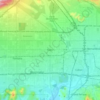
Nom : Carte topographique Rialto, altitude, relief.
Lieu : Rialto, San Bernardino County, California, United States (34.02459 -117.43679 34.18401 -117.34104)
Altitude moyenne : 387 m
Altitude minimum : 254 m
Altitude maximum : 864 m