
Carte topographique Bear Lake County
Carte interactive
Cliquez sur la carte pour afficher l’altitude.
À propos de cette carte
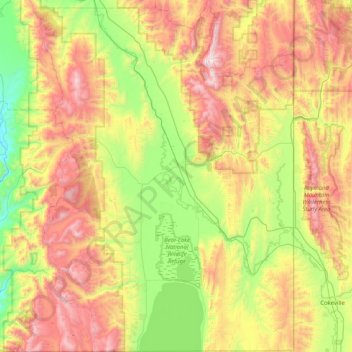
Nom : Carte topographique Bear Lake County, altitude, relief.
Lieu : Bear Lake County, Idaho, United States of America (41.99952 -111.63420 42.60329 -111.04668)
Altitude moyenne : 2 095 m
Altitude minimum : 1 488 m
Altitude maximum : 3 014 m
The county is named after Bear Lake, a large alpine lake at an elevation of 5,924 feet (1,806 m) above sea level. The northern half of the 20-mile-long (32 km) lake is in Idaho, the southern half in Utah. The county was established in 1875 in the Idaho Territory, fifteen years before statehood.
Autres cartes topographiques
Cliquez sur une carte pour visualiser sa topographie, son altitude et son relief.
Boise
United States of America > Idaho > Boise
Boise, Ada County, Idaho, United States of America
Altitude moyenne : 974 m
Basalt
United States of America > Idaho > Basalt
Basalt, Bingham County, Idaho, 83218, United States of America
Altitude moyenne : 1 398 m
Corbett Slough Canal
United States of America > Idaho
Corbett Slough Canal, Bingham County, Idaho, 83221-3339, United States of America
Altitude moyenne : 1 377 m
Lemhi County
United States of America > Idaho
Lemhi County, Idaho, United States of America
Altitude moyenne : 2 146 m