Géolocaliser

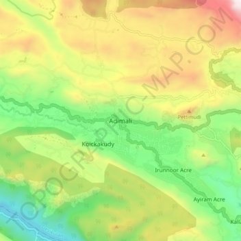
Carte topographique Adimali

Cliquez sur la carte pour afficher l’altitude.

Adimali

Adimali generally has a cool climate throughout the year, typical of the higher altitudes, though not as cold as Munnar. Temperatures rarely exceed 26 degrees and never drop below 10 degrees as it usually stays around 17-24 degrees. December and January are cooler than other months. Adimali is a place with heavy rainfall mostly throughout the year and it is heaviest during the June–September season of southwest monsoon. Rains in Adimali sometimes continue for hours or even days without any dry spell, which may bring the town to a standstill.

Wikipedia (CC-BY-SA 3.0)

À propos de cette carte

Nom : Carte topographique Adimali, altitude, relief.

Lieu : Adimali, Devikulam, Idukki, Kerala, 685561, India (9.97443 76.91546 10.05443 76.99546)

Altitude moyenne : 786 m

Altitude minimum : 177 m

Altitude maximum : 1 633 m

Autres cartes topographiques

Cliquez sur une carte pour visualiser sa topographie, son altitude et son relief.

Viripara

India > Kerala > Devikulam

Altitude moyenne : 1 143 m

Pallivasal

India > Kerala > Devikulam > Pallivasal

Altitude moyenne : 1 304 m

Pothupara

India > Kerala > Devikulam > Ellakkal

Altitude moyenne : 769 m

Thalamali

India > Kerala > Devikulam > Adimali

Altitude moyenne : 885 m

Anaimudi River

India > Kerala > Devikulam

Altitude moyenne : 1 430 m

Anamalai

India > Kerala > Devikulam

Altitude moyenne : 2 023 m

Munipara

India > Kerala > Devikulam > Mankulam

Altitude moyenne : 922 m

Eravikulam National Park

India > Kerala > Devikulam > Lakkomukudi

Altitude moyenne : 1 701 m

Mattupetty Dam

India > Kerala > Devikulam > Mattupetty

Altitude moyenne : 1 665 m

Anamalai

India > Kerala > Devikulam

Altitude moyenne : 2 023 m

Équipez-vous pour votre prochaine aventure :

🧥Veste Coupe-Vent - Couche légère et compacte pour se protéger du vent en altitude
🎒Sac à Dos 30 Litres - Volume idéal pour une journée d'exploration topographique
📦Sacs étanches - Protection du matériel contre l’humidité
📱Support Smartphone Guidon - Fixation robuste pour utiliser les cartes topo à vélo
🌧️Poncho de Pluie Respirant - Protection intégrale contre les intempéries en montagne

En tant que Partenaire Amazon, ce site perçoit une commission sur les achats éligibles sans surcoût pour vous.