
Carte topographique Chamblee
Carte interactive
Cliquez sur la carte pour afficher l’altitude.
À propos de cette carte
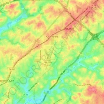
Nom : Carte topographique Chamblee, altitude, relief.
Lieu : Chamblee, DeKalb County, Georgia, 30341, United States (33.84057 -84.32248 33.91988 -84.27301)
Altitude moyenne : 297 m
Altitude minimum : 257 m
Altitude maximum : 337 m
Autres cartes topographiques
Cliquez sur une carte pour visualiser sa topographie, son altitude et son relief.
Brookhaven
United States > Georgia > DeKalb County
Brookhaven, DeKalb County, Georgia, United States
Altitude moyenne : 293 m
Candler-McAfee
United States > Georgia > DeKalb County
Candler-McAfee, DeKalb County, Georgia, 30032, United States
Altitude moyenne : 288 m
Avondale Estates
United States > Georgia > DeKalb County
Avondale Estates, DeKalb County, Georgia, United States
Altitude moyenne : 313 m
Tucker
United States > Georgia > DeKalb County > Tucker
Tucker, DeKalb County, Georgia, 30084, United States
Altitude moyenne : 317 m
Dunwoody
United States > Georgia > DeKalb County
Dunwoody, DeKalb County, Georgia, United States
Altitude moyenne : 313 m
Redan
United States > Georgia > DeKalb County > Redan
Redan, DeKalb County, Georgia, 30088-3433, United States
Altitude moyenne : 283 m
Pinehurst
United States > Georgia > DeKalb County > Pinehurst
Pinehurst, DeKalb County, Georgia, 30034-5209, United States
Altitude moyenne : 257 m
Clarkston
United States > Georgia > DeKalb County > Clarkston
Clarkston, DeKalb County, Georgia, 30021, United States
Altitude moyenne : 307 m