
Carte topographique Zittig
Carte interactive
Cliquez sur la carte pour afficher l’altitude.
À propos de cette carte
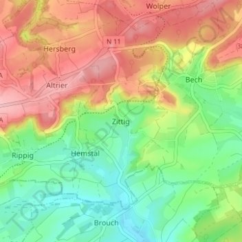
Nom : Carte topographique Zittig, altitude, relief.
Lieu : Zittig, Bech, Canton Echternach, 6255, Luxembourg (49.72511 6.32397 49.76511 6.36397)
Altitude moyenne : 324 m
Altitude minimum : 254 m
Altitude maximum : 409 m
Autres cartes topographiques
Cliquez sur une carte pour visualiser sa topographie, son altitude et son relief.
Mullerthal
Luxembourg > Canton Echternach > Waldbillig
Mullerthal, Waldbillig, Canton Echternach, 6245, Luxembourg
Altitude moyenne : 313 m
Echternach
Luxembourg > Canton Echternach
Echternach, Canton Echternach, Luxembourg
Altitude moyenne : 284 m
Beaufort
Luxembourg > Canton Echternach
Beaufort, Canton Echternach, Luxembourg
Altitude moyenne : 326 m
Waldbillig
Luxembourg > Canton Echternach
Waldbillig, Canton Echternach, Luxembourg
Altitude moyenne : 329 m