
Carte topographique Teresina
Carte interactive
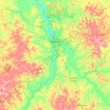
Cliquez sur la carte pour afficher l’altitude.
À propos de cette carte
Nom : Carte topographique Teresina, altitude, relief.
Altitude moyenne : 134 m
Altitude minimum : 43 m
Altitude maximum : 288 m
Teresina is located on the east side of the Parnaíba river at the border with Maranhão state, at an altitude of about 72 meters. The city faces the city of Timon across the river and is situated between the Parnaíba river and its tributary the Poti River. The two rivers join at the city's northern end, where there is an environmental park with gazebos. Teresina is the largest capital in the northeastern territorial extension, at 1,756 km2.
Autres cartes topographiques
Cliquez sur une carte pour visualiser sa topographie, son altitude et son relief.
Altos
Brazil > Piauí > Região Integrada de Desenvolvimento da Grande Teresina
Altos, Região Geográfica Imediata de Teresina, Região Integrada de Desenvolvimento da Grande Teresina, Região Geográfica Intermediária de Teresina, Piauí, Northeast Region, 64290-000, Brazil
Altitude moyenne : 161 m
Beneditinos
Brazil > Piauí > Região Integrada de Desenvolvimento da Grande Teresina
Beneditinos, Região Geográfica Imediata de Teresina, Região Integrada de Desenvolvimento da Grande Teresina, Região Geográfica Intermediária de Teresina, Piauí, Northeast Region, 64380-000, Brazil
Altitude moyenne : 135 m
União
Brazil > Piauí > Região Integrada de Desenvolvimento da Grande Teresina
União, Região Geográfica Imediata de Teresina, Região Integrada de Desenvolvimento da Grande Teresina, Região Geográfica Intermediária de Teresina, Piauí, Northeast Region, 64120-000, Brazil
Altitude moyenne : 97 m