
Carte topographique Morning View
Carte interactive
Cliquez sur la carte pour afficher l’altitude.
À propos de cette carte
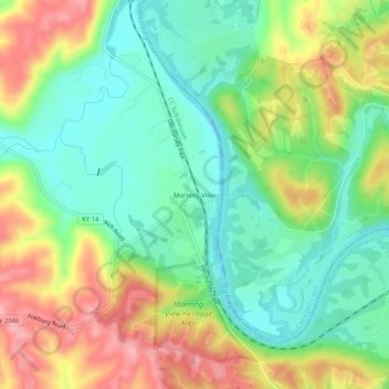
Nom : Carte topographique Morning View, altitude, relief.
Lieu : Morning View, Kenton County, Kentucky, 41063, United States (38.81201 -84.47633 38.85201 -84.43633)
Altitude moyenne : 192 m
Altitude minimum : 140 m
Altitude maximum : 269 m
Autres cartes topographiques
Cliquez sur une carte pour visualiser sa topographie, son altitude et son relief.
Villa Hills
United States > Kentucky > Kenton County
Villa Hills, Kenton County, Kentucky, United States
Altitude moyenne : 224 m
Taylor Mill
United States > Kentucky > Kenton County
Taylor Mill, Kenton County, Kentucky, 41015, United States
Altitude moyenne : 211 m
Covington
United States > Kentucky > Kenton County > Covington
Covington, Kenton County, Kentucky, United States
Altitude moyenne : 215 m
Sunny Acres
United States > Kentucky > Kenton County > Taylor Mill > Sunny Acres
Sunny Acres, Taylor Mill, Kenton County, Kentucky, 41015, United States
Altitude moyenne : 216 m
Lakeside Park
United States > Kentucky > Kenton County
Lakeside Park, Kenton County, Kentucky, 41017, United States
Altitude moyenne : 255 m