Géolocaliser

Carte topographique Ries

Carte interactive

Cliquez sur la carte pour afficher l’altitude.

À propos de cette carte

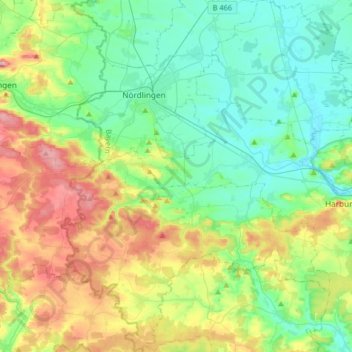
Nom : Carte topographique Ries, altitude, relief.

Lieu : Ries, Landkreis Donau-Ries, Bavaria, Germany (48.69473 10.41207 48.90927 10.68433)

Altitude moyenne : 484 m

Altitude minimum : 404 m

Altitude maximum : 672 m

Autres cartes topographiques

Cliquez sur une carte pour visualiser sa topographie, son altitude et son relief.

Harburg (Schwaben)

Germany > Bavaria > Landkreis Donau-Ries

Harburg (Schwaben), Landkreis Donau-Ries, Bavaria, 86655, Germany

Altitude moyenne : 473 m

Rain

Germany > Bavaria > Landkreis Donau-Ries

Rain, Rain (Schwaben), Landkreis Donau-Ries, Bavaria, 86641, Germany

Altitude moyenne : 414 m

Hühnerberg

Germany > Bavaria > Landkreis Donau-Ries > Harburg (Schwaben)

Hühnerberg, Harburg (Schwaben), Landkreis Donau-Ries, Bavaria, 86655, Germany

Altitude moyenne : 436 m

Rain

Germany > Bavaria > Landkreis Donau-Ries > Rain > Rain

Rain, Rain (Schwaben), Landkreis Donau-Ries, Bavaria, 86641, Germany

Altitude moyenne : 405 m

Nördlingen

Germany > Bavaria > Landkreis Donau-Ries

Nördlingen, Landkreis Donau-Ries, Bavaria, Germany

Altitude moyenne : 453 m

Donauwörth

Germany > Bavaria > Landkreis Donau-Ries

Donauwörth, Landkreis Donau-Ries, Bavaria, 86609, Germany

Altitude moyenne : 443 m