
Carte topographique Sudden Valley
Carte interactive
Cliquez sur la carte pour afficher l’altitude.
À propos de cette carte
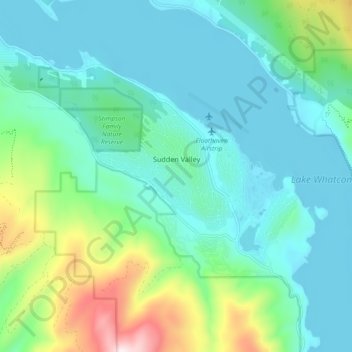
Nom : Carte topographique Sudden Valley, altitude, relief.
Lieu : Sudden Valley, Whatcom County, Washington, United States (48.69076 -122.39572 48.74909 -122.30380)
Altitude moyenne : 239 m
Altitude minimum : 87 m
Altitude maximum : 800 m
Autres cartes topographiques
Cliquez sur une carte pour visualiser sa topographie, son altitude et son relief.
Point Roberts
United States > Washington > Whatcom County > Point Roberts
Point Roberts, Whatcom County, Washington, 98281, United States
Altitude moyenne : 9 m
Birch Bay
United States > Washington > Whatcom County
Birch Bay, Whatcom County, Washington, United States
Altitude moyenne : 21 m
Maple Falls
United States > Washington > Whatcom County
Maple Falls, Whatcom County, Washington, United States
Altitude moyenne : 442 m
Ferndale
United States > Washington > Whatcom County
Ferndale, Whatcom County, Washington, United States
Altitude moyenne : 29 m
Lynden
United States > Washington > Whatcom County
Lynden, Whatcom County, Washington, United States
Altitude moyenne : 26 m
Sumas
United States > Washington > Whatcom County
Sumas, Whatcom County, Washington, 98295, United States
Altitude moyenne : 15 m
Mount Baker
United States > Washington > Whatcom County
Mount Baker, Whatcom County, Washington, United States
Altitude moyenne : 2 699 m
Bellingham
United States > Washington > Whatcom County
Bellingham, Whatcom County, Washington, United States
Altitude moyenne : 89 m
Blaine
United States > Washington > Whatcom County
Blaine, Whatcom County, Washington, 98231, United States
Altitude moyenne : 23 m
Newhalem
United States > Washington > Whatcom County
Newhalem, Whatcom County, Washington, United States
Altitude moyenne : 492 m