
Carte topographique Hopkins County
Carte interactive
Cliquez sur la carte pour afficher l’altitude.
À propos de cette carte
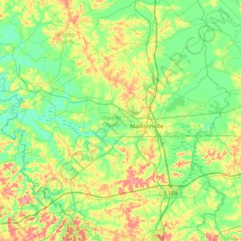
Nom : Carte topographique Hopkins County, altitude, relief.
Lieu : Hopkins County, Kentucky, USA (37.10516 -87.85183 37.56998 -87.29575)
Altitude moyenne : 134 m
Altitude minimum : 100 m
Altitude maximum : 219 m
Autres cartes topographiques
Cliquez sur une carte pour visualiser sa topographie, son altitude et son relief.
Forest Hills
USA > Kentucky > Forest Hills
Forest Hills, Jefferson County, Kentucky, USA
Altitude moyenne : 202 m
Mammoth Cave
USA > Kentucky > Mammoth Cave
Mammoth Cave, Edmonson County, Kentucky, USA
Altitude moyenne : 214 m
Deadman's Island
Deadman's Island, Henderson County, Kentucky, USA
Altitude moyenne : 112 m
Stephens Lake
Stephens Lake, Hicks Road, Beelerton, Hickman County, Kentucky, 42085, USA
Altitude moyenne : 112 m
Murray Hill
USA > Kentucky > Murray Hill
Murray Hill, Jefferson County, Kentucky, USA
Altitude moyenne : 194 m
Georgetown
USA > Kentucky > Georgetown
Georgetown, Scott County, Kentucky, 40324, USA
Altitude moyenne : 265 m