
Carte topographique White River
Carte interactive
Cliquez sur la carte pour afficher l’altitude.
À propos de cette carte
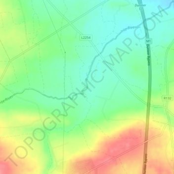
Nom : Carte topographique White River, altitude, relief.
Altitude moyenne : 75 m
Altitude minimum : 44 m
Altitude maximum : 119 m
Autres cartes topographiques
Cliquez sur une carte pour visualiser sa topographie, son altitude et son relief.
Termonfeckin
Termonfeckin, Termonfeckin ED, The Borough District of Drogheda, County Louth, Leinster, Ireland
Altitude moyenne : 16 m
The Borough District of Drogheda
The Borough District of Drogheda, County Louth, Leinster, Ireland
Altitude moyenne : 50 m
Collon
Collon, Collon ED, The Municipal District of Ardee, County Louth, Leinster, Ireland
Altitude moyenne : 142 m
Drumlin ( E.D. Dunleer)
Drumlin ( E.D. Dunleer), Dunleer ED, The Municipal District of Ardee, County Louth, Leinster, Ireland
Altitude moyenne : 49 m
Greatwood
Greatwood, Clonkeen ED, The Municipal District of Ardee, County Louth, Leinster, Ireland
Altitude moyenne : 40 m
Dundalk
Ireland > County Louth > Dundalk
Dundalk, The Municipal District of Dundalk, County Louth, Leinster, A91 RC44, Ireland
Altitude moyenne : 16 m