
Carte topographique Obi Islands
Carte interactive
Cliquez sur la carte pour afficher l’altitude.
À propos de cette carte
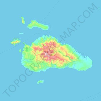
Nom : Carte topographique Obi Islands, altitude, relief.
Altitude moyenne : 61 m
Altitude minimum : 0 m
Altitude maximum : 1 537 m
Autres cartes topographiques
Cliquez sur une carte pour visualiser sa topographie, son altitude et son relief.
Bacan Island
Indonesia > North Maluku > Halmahera Selatan
Bacan Island, Halmahera Selatan, North Maluku, 97791, Indonesia
Altitude moyenne : 127 m
Mandioli Island
Indonesia > North Maluku > Halmahera Selatan > Waya
Mandioli Island, Waya, Halmahera Selatan, North Maluku, Indonesia
Altitude moyenne : 42 m
Obira
Indonesia > North Maluku > Halmahera Selatan
Obira, Halmahera Selatan, North Maluku, Indonesia
Altitude moyenne : 118 m