
Carte topographique Puerto Carreño
Carte interactive
Cliquez sur la carte pour afficher l’altitude.
À propos de cette carte
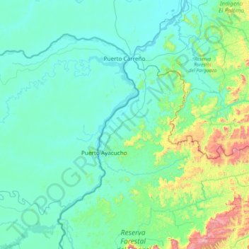
Nom : Carte topographique Puerto Carreño, altitude, relief.
Lieu : Puerto Carreño, Vichada, RAP Llanos, Colombia (5.30179 -68.82483 6.32878 -67.40344)
Altitude moyenne : 194 m
Altitude minimum : 33 m
Altitude maximum : 1 599 m
The area of the municipality is within the llanos plains which cover large areas in Colombia and Venezuela that are rich in biodiversity. Geologically the municipality of Puerto Carreño lies on the Guiana Shield mostly made up by Cenozoic and Precambric formations, with some low altitude mountains such as the Mounts of Casuarito and the Hormiga and Guaripa mountains.
Autres cartes topographiques
Cliquez sur une carte pour visualiser sa topographie, son altitude et son relief.