
Carte topographique Pitalito
Carte interactive
Cliquez sur la carte pour afficher l’altitude.
À propos de cette carte
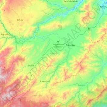
Nom : Carte topographique Pitalito, altitude, relief.
Lieu : Pitalito, Sur, Huila, 417030, Colombia (1.65724 -76.32189 1.97668 -75.96183)
Altitude moyenne : 1 635 m
Altitude minimum : 969 m
Altitude maximum : 2 762 m
The valley itself lies at about 1,300 meters above sea level. All the surrounding mountains grow coffee with the average farm having about 6 hectares and about 5,000 trees per hectare. The soil is volcanic, providing plenty of organic nutrients for the high altitude coffee.
Autres cartes topographiques
Cliquez sur une carte pour visualiser sa topographie, son altitude et son relief.
Reserva Natural de la Sociedad Civil La Esperanza
Reserva Natural de la Sociedad Civil La Esperanza, Neiva, Norte, Huila, RAP (Especial) Central, Colombia
Altitude moyenne : 1 439 m
Carmen De Bolívar
Colombia > Huila > Santa María
Carmen De Bolívar, Santa María, Norte, Huila, RAP (Especial) Central, Colombia
Altitude moyenne : 2 596 m
Santa María
Santa María, Norte, Huila, RAP (Especial) Central, Colombia
Altitude moyenne : 1 864 m
San Augustin
San Augustin, Colombia, Norte, Huila, Colombia
Altitude moyenne : 1 658 m
Campoalegre
Campoalegre, Norte, Huila, RAP (Especial) Central, Colombia
Altitude moyenne : 1 063 m
Buenos Aires
Buenos Aires, Palermo, Norte, Huila, Colombia
Altitude moyenne : 801 m
Perímetro Urbano Neiva
Perímetro Urbano Neiva, Neiva, Norte, Huila, RAP (Especial) Central, Colombia
Altitude moyenne : 469 m
Salto de Bordones
Salto de Bordones, Isnos, Sur, Huila, Colombia
Altitude moyenne : 1 728 m
Desierto de la Tatacoa
Colombia > Huila > Villavieja
Desierto de la Tatacoa, Villavieja, Norte, Huila, Colombia
Altitude moyenne : 448 m
Nueva Irlanda
Nueva Irlanda, La Plata, Occidente, Huila, Colombia
Altitude moyenne : 1 632 m