
Carte topographique Chakpikarong
Carte interactive
Cliquez sur la carte pour afficher l’altitude.
À propos de cette carte
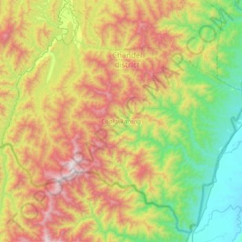
Nom : Carte topographique Chakpikarong, altitude, relief.
Lieu : Chakpikarong, Chandel, Manipur, 795102, India (23.83362 93.73925 24.26735 94.25538)
Altitude moyenne : 927 m
Altitude minimum : 137 m
Altitude maximum : 2 319 m
Autres cartes topographiques
Cliquez sur une carte pour visualiser sa topographie, son altitude et son relief.
Tengnoupal
India > Manipur > Tengnoupal tehsil
Tengnoupal, Tengnoupal tehsil, Tengnoupal District, Manipur, India
Altitude moyenne : 1 220 m
Loktak Lake
India > Manipur > Bishnupur > Thanga
Loktak Lake, Thanga, Bishnupur, Manipur, India
Altitude moyenne : 772 m
Imphal
India > Manipur > Lamphelpat
Imphal, Lamphelpat, Imphal West District, Manipur, 795001, India
Altitude moyenne : 861 m