
Carte topographique Koto
Carte interactive
Cliquez sur la carte pour afficher l’altitude.
À propos de cette carte
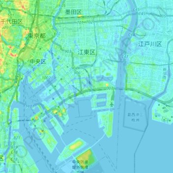
Nom : Carte topographique Koto, altitude, relief.
Lieu : Koto, Tokyo, Japan (35.58887 139.76672 35.70809 139.84855)
Altitude moyenne : 5 m
Altitude minimum : -10 m
Altitude maximum : 56 m
Kōtō occupies a position on the waterfront of Tokyo Bay sandwiched between the wards of Chūō and Edogawa. Its inland boundary is with Sumida. Much of the land is reclaimed, The northern part is old reclaimed land, and the elevation is very low(below sea level. The southern part is relatively new, but there are few old temples or shrines.
Autres cartes topographiques
Cliquez sur une carte pour visualiser sa topographie, son altitude et son relief.
Niseko
Niseko, Abuta County, Shiribeshi Subprefecture, Hokkaido Prefecture, Japan
Altitude moyenne : 339 m
Karuizawa
Karuizawa, Kitasaku County, Nagano Prefecture, Japan
Altitude moyenne : 1 117 m
Ishigaki
Ishigaki, Okinawa Prefecture, Kyushu Region, Japan
Altitude moyenne : 8 m
Mount Fuji
Japan > Sunto County > Oyama
Mount Fuji, Oyama, Sunto County, Shizuoka Prefecture, Chubu Region, Japan
Altitude moyenne : 3 261 m
Higashikawa
Higashikawa, Kamikawa County, Kamikawa Subprefecture, Hokkaido Prefecture, Japan
Altitude moyenne : 342 m
Tsukiji
Japan > Akita Prefecture > Akita > Tsukiji
Tsukiji, Akita, Akita Prefecture, 010-0013, Japan
Altitude moyenne : 10 m
Minamiyoshidamachi
Japan > Ehime Prefecture > Matsuyama > Minamiyoshidamachi
Minamiyoshidamachi, Matsuyama, Ehime Prefecture, 791-8042, Japan
Altitude moyenne : 7 m
Kikuyou
Kikuyou, Kikuchi County, Kumamoto Prefecture, 869-1103, Japan
Altitude moyenne : 99 m
Miyashitadori
Japan > Hokkaidō Prefecture > Asahikawa > Miyashitadori
Miyashitadori, Asahikawa, Kamikawa Subprefecture, Hokkaidō Prefecture, 070-0030, Japan
Altitude moyenne : 118 m
湊入船町
Japan > Chubu Region > Toyama > 湊入船町
湊入船町, Toyama, Toyama Prefecture, Chubu Region, 930-0001, Japan
Altitude moyenne : 13 m
Minamikoma District
Nanbu, Minamikoma District, Yamanashi Prefecture, Chubu Region, Japan
Altitude moyenne : 641 m
Abuta
Toyako, Abuta, Iburi Subprefecture, Hokkaidō Prefecture, Hokkaidō Region, Japan
Altitude moyenne : 176 m
Ooshima County
Wadomari, Ooshima County, Kagoshima Prefecture, Kyushu Region, Japan
Altitude moyenne : 3 m
Hata County
Otsuki, Hata County, Kochi Prefecture, Shikoku Region, Japan
Altitude moyenne : 42 m