
Carte topographique Shoal Creek Farms
Carte interactive
Cliquez sur la carte pour afficher l’altitude.
À propos de cette carte
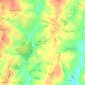
Nom : Carte topographique Shoal Creek Farms, altitude, relief.
Altitude moyenne : 205 m
Altitude minimum : 172 m
Altitude maximum : 232 m
Autres cartes topographiques
Cliquez sur une carte pour visualiser sa topographie, son altitude et son relief.
Spring Valley Estates
United States > Georgia > Athens-Clarke County > Athens-Clarke County Unified Government
Spring Valley Estates, Athens-Clarke County Unified Government, Athens-Clarke County, Georgia, 30601, United States
Altitude moyenne : 218 m
Eastmeadow
United States > Georgia > Athens-Clarke County > Athens-Clarke County Unified Government
Eastmeadow, Athens-Clarke County Unified Government, Athens-Clarke County, Georgia, 30605, United States
Altitude moyenne : 223 m
Jefferson Valley
United States > Georgia > Athens-Clarke County > Athens-Clarke County Unified Government
Jefferson Valley, Athens-Clarke County Unified Government, Athens-Clarke County, Georgia, 30607, United States
Altitude moyenne : 223 m
Rollingwood
United States > Georgia > Athens-Clarke County > Athens-Clarke County Unified Government
Rollingwood, Athens-Clarke County Unified Government, Athens-Clarke County, Georgia, 30608, United States
Altitude moyenne : 210 m