
Carte topographique Norfolk
Carte interactive
Cliquez sur la carte pour afficher l’altitude.
Norfolk
According to the United States Census Bureau, the town has a total area of 46.4 square miles (120.2 km2), of which 45.3 square miles (117.4 km2) are land and 1.1 square miles (2.9 km2), or 2.38%, are water. The town is located in the Litchfield Hills portion of the Appalachian mountain range. Norfolk's elevation is 1,230 feet (370 m) above sea level, and the town is sometimes called "the Icebox of Connecticut" for its severe winters and particularly cool summers.
À propos de cette carte
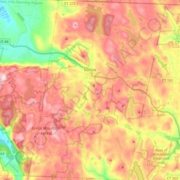
Nom : Carte topographique Norfolk, altitude, relief.
Altitude moyenne : 404 m
Altitude minimum : 203 m
Altitude maximum : 559 m