
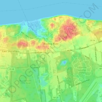
Carte topographique Wading River
Carte interactive
Cliquez sur la carte pour afficher l’altitude.
À propos de cette carte
Nom : Carte topographique Wading River, altitude, relief.
Altitude moyenne : 23 m
Altitude minimum : -4 m
Altitude maximum : 66 m
The earliest English records show a settlement known as Wading River was founded by eight colonial families. "The spot for the village was chosen with care. There was a stream adequate for water power and abounding in seafood...good water for drinking...soil rich enough to grow essential crops, woodland for fuel, building material and food, topography to offer protection from the elements, meadowland for its grass."
Autres cartes topographiques
Cliquez sur une carte pour visualiser sa topographie, son altitude et son relief.
Riverhead
United States > New York > Suffolk County > Town of Riverhead
Riverhead, Town of Riverhead, Suffolk County, New York, United States
Altitude moyenne : 13 m
Calverton
United States > New York > Suffolk County > Town of Riverhead
Calverton, Town of Riverhead, Suffolk County, New York, 11933, United States
Altitude moyenne : 26 m