
Carte topographique Gemeinde Zellberg
Carte interactive
Cliquez sur la carte pour afficher l’altitude.
À propos de cette carte
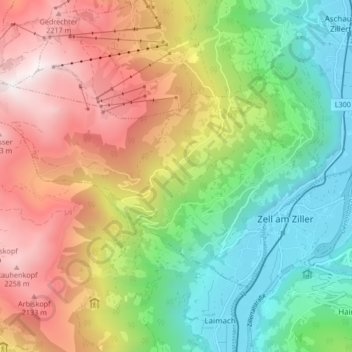
Nom : Carte topographique Gemeinde Zellberg, altitude, relief.
Lieu : Gemeinde Zellberg, Bezirk Schwaz, Tyrol, 6277, Austria (47.22265 11.80624 47.25831 11.88989)
Altitude moyenne : 1 352 m
Altitude minimum : 560 m
Altitude maximum : 2 423 m
Autres cartes topographiques
Cliquez sur une carte pour visualiser sa topographie, son altitude et son relief.
Marktgemeinde Mayrhofen
Austria > Tyrol > Bezirk Schwaz
Marktgemeinde Mayrhofen, Bezirk Schwaz, Tyrol, Austria
Altitude moyenne : 1 983 m
Gemeinde Tux
Austria > Tyrol > Bezirk Schwaz
Gemeinde Tux, Bezirk Schwaz, Tyrol, Austria
Altitude moyenne : 2 110 m
Schwaz
Austria > Tyrol > Bezirk Schwaz
Schwaz, Stadt Schwaz, Bezirk Schwaz, Tyrol, 6130, Austria
Altitude moyenne : 951 m