
Carte topographique Çaykara
Carte interactive
Cliquez sur la carte pour afficher l’altitude.
À propos de cette carte
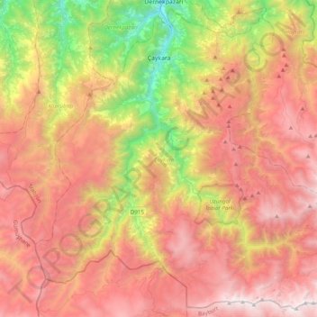
Nom : Carte topographique Çaykara, altitude, relief.
Lieu : Çaykara, Trabzon, Black Sea Region, Turkey (40.51354 40.09034 40.79261 40.47893)
Altitude moyenne : 1 788 m
Altitude minimum : 208 m
Altitude maximum : 3 191 m
Çaykara (Romeika: Kadahor, Κατωχώρι) is a municipality and district of Trabzon Province, Turkey. Its area is 574 km2, and its population is 13,070 (2022). As of 2023, the Mayor of Çaykara is Hanefi Tok (AKP). Çaykara village lies in a V-shaped valley along the Solaklı River in the Pontic Mountains, at an elevation of around 300 metres. Çaykara district lies to the south of Dernekpazarı (Kondu) and forms the upper part of the Of-valley system ('Solaklı Vadisi' in Turkish), with peaks reaching to over 3300 meters. The western half of İkizdere district - which lies just east of Çaykara and is now part of Rize province - was historically also part of the same administrative and cultural region. Large swathes of the district are made up of old-growth temperate broadleaf and mixed forest, gradually making way for alpine tundra at higher altitudes.
Autres cartes topographiques
Cliquez sur une carte pour visualiser sa topographie, son altitude et son relief.