
Carte topographique Schwalbach
Carte interactive
Cliquez sur la carte pour afficher l’altitude.
À propos de cette carte
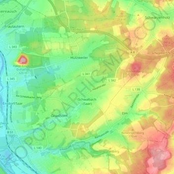
Nom : Carte topographique Schwalbach, altitude, relief.
Lieu : Schwalbach, Landkreis Saarlouis, Saarland, 66773, Germany (49.28203 6.78262 49.33401 6.88284)
Altitude moyenne : 236 m
Altitude minimum : 175 m
Altitude maximum : 328 m
Autres cartes topographiques
Cliquez sur une carte pour visualiser sa topographie, son altitude et son relief.
Michelbach
Germany > Saarland > Landkreis Saarlouis
Michelbach, Schmelz, Landkreis Saarlouis, Saarland, 66839, Germany
Altitude moyenne : 288 m
Saarwellingen
Germany > Saarland > Landkreis Saarlouis
Saarwellingen, Landkreis Saarlouis, Saarland, 66793, Germany
Altitude moyenne : 235 m
Saarlouis
Germany > Saarland > Landkreis Saarlouis > Saarlouis
Saarlouis, Landkreis Saarlouis, Saarland, 66740, Germany
Altitude moyenne : 222 m