
Carte topographique Meires
Carte interactive
Cliquez sur la carte pour afficher l’altitude.
À propos de cette carte
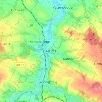
Nom : Carte topographique Meires, altitude, relief.
Altitude moyenne : 513 m
Altitude minimum : 475 m
Altitude maximum : 565 m
Autres cartes topographiques
Cliquez sur une carte pour visualiser sa topographie, son altitude et son relief.
Kottschallings
Austria > Lower Austria > Bezirk Waidhofen an der Thaya
Kottschallings, Windigsteig, Bezirk Waidhofen an der Thaya, Lower Austria, 3841, Austria
Altitude moyenne : 512 m
Jaudling
Austria > Lower Austria > Bezirk Waidhofen an der Thaya
Jaudling, Vitis, Bezirk Waidhofen an der Thaya, Lower Austria, 3902, Austria
Altitude moyenne : 563 m
Jasnitz
Austria > Lower Austria > Bezirk Waidhofen an der Thaya > Gemeinde Waidhofen an der Thaya
Jasnitz, Gemeinde Waidhofen an der Thaya, Bezirk Waidhofen an der Thaya, Lower Austria, 3830, Austria
Altitude moyenne : 506 m