
Carte topographique Żywiec
Carte interactive
Cliquez sur la carte pour afficher l’altitude.
À propos de cette carte
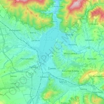
Nom : Carte topographique Żywiec, altitude, relief.
Lieu : Żywiec, Żywiec County, Silesian Voivodeship, 34-300, Poland (49.64987 19.15181 49.76312 19.26800)
Altitude moyenne : 431 m
Altitude minimum : 319 m
Altitude maximum : 857 m
Autres cartes topographiques
Cliquez sur une carte pour visualiser sa topographie, son altitude et son relief.
Majdany
Poland > Silesian Voivodeship > Żywiec County > Rychwałd
Majdany, Rychwałd, gmina Gilowice, Żywiec County, Silesian Voivodeship, 34-321, Poland
Altitude moyenne : 401 m
Wieczorek
Poland > Silesian Voivodeship > Żywiec County > Zwardoń
Wieczorek, Zwardoń, gmina Rajcza, Żywiec County, Silesian Voivodeship, 34-373, Poland
Altitude moyenne : 720 m
Koszarawa
Poland > Silesian Voivodeship > Żywiec County
Koszarawa, gmina Koszarawa, Żywiec County, Silesian Voivodeship, 34-332, Poland
Altitude moyenne : 678 m
Żywiec
Poland > Silesian Voivodeship > Żywiec County > Żywiec
Żywiec, Żywiec County, Silesian Voivodeship, Poland
Altitude moyenne : 437 m