
Carte topographique Gauting
Carte interactive
Cliquez sur la carte pour afficher l’altitude.
À propos de cette carte
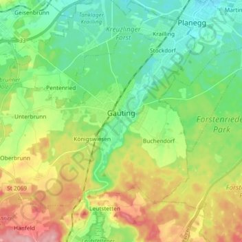
Nom : Carte topographique Gauting, altitude, relief.
Lieu : Gauting, Landkreis Starnberg, Bayern, 82131, Deutschland (48.02768 11.27599 48.10133 11.42019)
Altitude moyenne : 593 m
Altitude minimum : 541 m
Altitude maximum : 687 m
Autres cartes topographiques
Cliquez sur une carte pour visualiser sa topographie, son altitude et son relief.
Pöcking
Deutschland > Bayern > Landkreis Starnberg
Pöcking, Landkreis Starnberg, Bayern, 82343, Deutschland
Altitude moyenne : 638 m
Söcking
Deutschland > Bayern > Landkreis Starnberg > Starnberg > Söcking
Söcking, Starnberg, Wörthsee, Landkreis Starnberg, Bayern, 82237, Deutschland
Altitude moyenne : 651 m