
Carte topographique Ohtawara
Carte interactive
Cliquez sur la carte pour afficher l’altitude.
À propos de cette carte
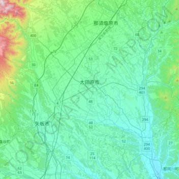
Nom : Carte topographique Ohtawara, altitude, relief.
Lieu : Ohtawara, Tochigi Prefecture, Japan (36.76840 139.92167 36.94835 140.26739)
Altitude moyenne : 276 m
Altitude minimum : 91 m
Altitude maximum : 1 265 m
Ōtawara is located in northeast Tochigi Prefecture in the foothills of the Nasu region. About 50% of Ōtawara is covered by rice fields with about 12% being mountains and forests. The average elevation of Ōtawara is 217.76 meters. Ōtawara is approximately 40 kilometers north of Utsunomiya, the capital of Tochigi, and approximately 50 km east of the historic city of Nikkō. The city is long in the east and west direction, and the eastern side of the city is bordered by Ibaraki and Fukushima prefectures. The Yamizo Mountains extend along the prefectural border with Ibaraki Prefecture in the eastern part of the prefecture. Rivers include the Naka River, which runs north–south in the eastern part of the city.
Autres cartes topographiques
Cliquez sur une carte pour visualiser sa topographie, son altitude et son relief.
Mount Fuji
Japan > Sunto County > Oyama
Mount Fuji, Oyama, Sunto County, Shizuoka Prefecture, Chubu Region, Japan
Altitude moyenne : 3 261 m
Ibaraki
Ibaraki, Higashiibaraki County, Ibaraki Prefecture, 311-3116, Japan
Altitude moyenne : 26 m
Maborikaigan 4-chome Park
Maborikaigan 4-chome Park, Maboricho 3-chome, Yokosuka, Kanagawa Prefecture, 238-8550, Japan
Altitude moyenne : 22 m
Lake Sanaru
Lake Sanaru, Hamamatsu, Shizuoka Prefecture, Chubu Region, Japan
Altitude moyenne : 16 m
Motoyama
Motoyama, Nagaoka County, Kochi Prefecture, 781-3601, Japan
Altitude moyenne : 679 m
Setouchi
Setouchi, Oshima County, Kagoshima Prefecture, Japan
Altitude moyenne : 26 m
Higashishirakawa
Higashishirakawa, Kamo County, Gifu Prefecture, Chubu Region, 509-1392, Japan
Altitude moyenne : 658 m
Nishikigaoka-chuo Park
Nishikigaoka-chuo Park, Nishikigaoka 2-chome, Aoba Ward, Sendai, Miyagi Prefecture, Japan
Altitude moyenne : 197 m