
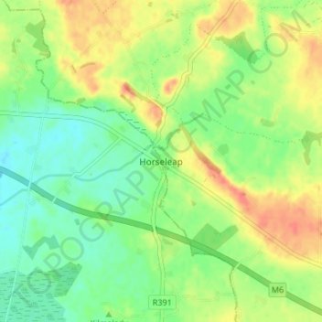
Carte topographique Horseleap
Carte interactive
Cliquez sur la carte pour afficher l’altitude.
À propos de cette carte
Nom : Carte topographique Horseleap, altitude, relief.
Altitude moyenne : 70 m
Altitude minimum : 50 m
Altitude maximum : 94 m
Autres cartes topographiques
Cliquez sur une carte pour visualiser sa topographie, son altitude et son relief.
Clara
Clara, Clara ED, The Municipal District of Tullamore, County Offaly, Leinster, Ireland
Altitude moyenne : 62 m
The Municipal District of Birr
The Municipal District of Birr, County Offaly, Leinster, Ireland
Altitude moyenne : 97 m
Wood
Wood, Ballyburly ED, The Municipal District of Edenderry, County Offaly, Leinster, Ireland
Altitude moyenne : 75 m
Shane Valley
Shane Valley, Edenderry Rural ED, The Municipal District of Edenderry, County Offaly, Leinster, R45 X951, Ireland
Altitude moyenne : 71 m
Down
Down, Mountbriscoe ED, The Municipal District of Edenderry, County Offaly, Leinster, Ireland
Altitude moyenne : 88 m