
Carte topographique Gifford Pinchot National Forest
Carte interactive
Cliquez sur la carte pour afficher l’altitude.
À propos de cette carte
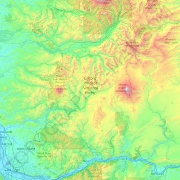
Nom : Carte topographique Gifford Pinchot National Forest, altitude, relief.
Altitude moyenne : 769 m
Altitude minimum : -1 m
Altitude maximum : 3 703 m
Gifford Pinchot National Forest is located in a mountainous region approximately between Mount St. Helens to the west, Mount Adams to the east, Mount Rainier National Park to the north, and the Columbia River to the south. This region of Southwest Washington is noted for its complex topography and volcanic geology. About 65 percent of the forest acreage is located in Skamania County. In descending order of land area the others are Lewis, Yakima, Cowlitz, and Klickitat counties.
Autres cartes topographiques
Cliquez sur une carte pour visualiser sa topographie, son altitude et son relief.
Spirit Lake
United States > Washington > Skamania County
Spirit Lake, Skamania County, Washington, United States
Altitude moyenne : 1 144 m
Mount Saint Helens
United States > Washington > Skamania County
Mount Saint Helens, Skamania County, Washington, United States
Altitude moyenne : 2 096 m