
Carte topographique Morton Island
Carte interactive
Cliquez sur la carte pour afficher l’altitude.
À propos de cette carte
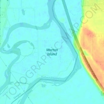
Nom : Carte topographique Morton Island, altitude, relief.
Altitude moyenne : 661 m
Altitude minimum : 652 m
Altitude maximum : 692 m
Autres cartes topographiques
Cliquez sur une carte pour visualiser sa topographie, son altitude et son relief.
Boring
United States of America > Oregon > Boring
Boring, Clackamas County, Oregon, 97009, United States of America
Altitude moyenne : 183 m
Rhododendron
United States of America > Oregon > Rhododendron
Rhododendron, The Villages at Mount Hood, Clackamas County, Oregon, 97049, United States of America
Altitude moyenne : 735 m
Iron Knob
United States of America > Oregon
Iron Knob, Jackson County, Oregon, United States of America
Altitude moyenne : 861 m
Wemme
United States of America > Oregon > Wemme
Wemme, The Villages at Mount Hood, Clackamas County, Oregon, 97067, United States of America
Altitude moyenne : 494 m
Barlow
United States of America > Oregon > Barlow
Barlow, Clackamas County, Oregon, United States of America
Altitude moyenne : 31 m
Lake County
United States of America > Oregon
Lake County, Oregon, United States of America
Altitude moyenne : 1 540 m
McKenzie River
United States of America > Oregon
McKenzie River, Lane County, Oregon, 97413, United States of America
Altitude moyenne : 431 m
Hillsboro
United States of America > Oregon > Hillsboro
Hillsboro, Washington County, Oregon, United States of America
Altitude moyenne : 53 m
Hail Creek
United States of America > Oregon
Hail Creek, Crook County, Oregon, United States of America
Altitude moyenne : 1 412 m