
Carte topographique Millarville
Carte interactive
Cliquez sur la carte pour afficher l’altitude.
À propos de cette carte
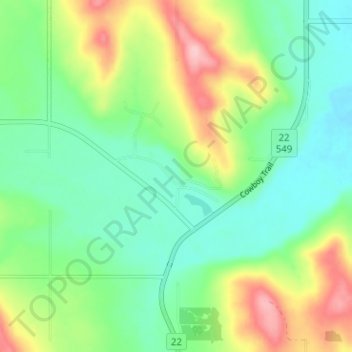
Nom : Carte topographique Millarville, altitude, relief.
Lieu : Millarville, Foothills County, Alberta, T0L 1K0, Canada (50.73815 -114.34538 50.77815 -114.30538)
Altitude moyenne : 1 220 m
Altitude minimum : 1 168 m
Altitude maximum : 1 323 m
Autres cartes topographiques
Cliquez sur une carte pour visualiser sa topographie, son altitude et son relief.
Red Deer Lake
Canada > Alberta > Foothills County
Red Deer Lake, Foothills County, Alberta, Canada
Altitude moyenne : 1 140 m
Cayley
Canada > Alberta > Foothills County
Cayley, Foothills County, Alberta, Canada
Altitude moyenne : 1 070 m