
Carte topographique Lüsens
Carte interactive
Cliquez sur la carte pour afficher l’altitude.
À propos de cette carte
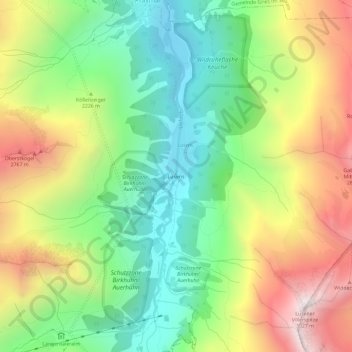
Nom : Carte topographique Lüsens, altitude, relief.
Altitude moyenne : 2 169 m
Altitude minimum : 1 594 m
Altitude maximum : 2 999 m
Autres cartes topographiques
Cliquez sur une carte pour visualiser sa topographie, son altitude et son relief.
Pforzheimer Hütte
Österreich > Tirol > Bezirk Innsbruck-Land > Gemeinde Sankt Sigmund im Sellrain
Pforzheimer Hütte, 19a, Via Mandani, Gemeinde Sankt Sigmund im Sellrain, Bezirk Innsbruck-Land, Tirol, 6184, Österreich
Altitude moyenne : 2 474 m