
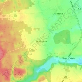
Carte topographique Sławutowo
Carte interactive
Cliquez sur la carte pour afficher l’altitude.
À propos de cette carte
Nom : Carte topographique Sławutowo, altitude, relief.
Altitude moyenne : 51 m
Altitude minimum : 16 m
Altitude maximum : 87 m
Autres cartes topographiques
Cliquez sur une carte pour visualiser sa topographie, son altitude et son relief.
Sławoszyno
Poland > Pomeranian Voivodeship > Puck County
Sławoszyno, gmina Krokowa, Puck County, Pomeranian Voivodeship, 84-110, Poland
Altitude moyenne : 23 m
Władysławowo
Poland > Pomeranian Voivodeship > Puck County
Władysławowo, Puck County, Pomeranian Voivodeship, Poland
Altitude moyenne : 11 m
Kartoszyno
Poland > Pomeranian Voivodeship > Puck County
Kartoszyno, gmina Krokowa, Puck County, Pomeranian Voivodeship, 84-110, Poland
Altitude moyenne : 36 m
Żelistrzewo
Poland > Pomeranian Voivodeship > Puck County
Żelistrzewo, gmina Puck, Puck County, Pomeranian Voivodeship, 84-122, Poland
Altitude moyenne : 25 m
Puck County
Poland > Pomeranian Voivodeship > Puck County
Puck County, Pomeranian Voivodeship, Poland
Altitude moyenne : 44 m