
Carte topographique Oingo Lake
Carte interactive
Cliquez sur la carte pour afficher l’altitude.
À propos de cette carte
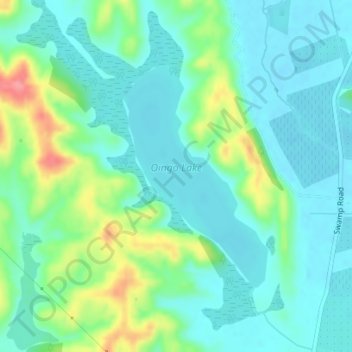
Nom : Carte topographique Oingo Lake, altitude, relief.
Altitude moyenne : 38 m
Altitude minimum : 15 m
Altitude maximum : 103 m
Autres cartes topographiques
Cliquez sur une carte pour visualiser sa topographie, son altitude et son relief.
Runanga Lake
Runanga Lake, Ohiti Road, Omahu, Hastings District, Hawke's Bay, 4175, New Zealand
Altitude moyenne : 73 m
Te Roto Kare
Te Roto Kare, State Highway 50, Kingsley Chatham, Omahu, Hastings District, Hawke's Bay, 4175, New Zealand
Altitude moyenne : 37 m