
Faire un don
Équipez-vous pour votre prochaine aventure :
En tant que Partenaire Amazon, ce site perçoit une commission sur les achats éligibles sans surcoût pour vous.
Carte topographique Cayey
Cliquez sur la carte pour afficher l’altitude.
Faire un don
Équipez-vous pour votre prochaine aventure :
En tant que Partenaire Amazon, ce site perçoit une commission sur les achats éligibles sans surcoût pour vous.
Cayey
Cayey's climate is humid, rainy and mild compared to lower-elevation areas of the island, the area of the town is nearly 1,500 feet (460 m) high, so the climate is subtropical high. In summer average high Temperatures are around 82 °F to 88 °F and 70 °F to 78 °F in winter, and low around 68 °F to 72 °F in summer and 57 °F to 63 °F in winter. The record maximum temperature is 94 °F (34 °C) and minimum 45 °F (7 °C). The average annual rainfall is 100 inches (2,540 mm) and maximum rainfall record in 24 hours is 20.87 inches (530 mm) of rain.
Faire un don
Équipez-vous pour votre prochaine aventure :
En tant que Partenaire Amazon, ce site perçoit une commission sur les achats éligibles sans surcoût pour vous.
À propos de cette carte
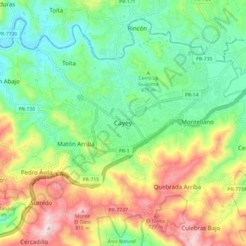
Nom : Carte topographique Cayey, altitude, relief.
Lieu : Cayey, Puerto Rico, 00736, United States (18.07269 -66.20628 18.15269 -66.12628)
Altitude moyenne : 489 m
Altitude minimum : 284 m
Altitude maximum : 840 m
Faire un don
Équipez-vous pour votre prochaine aventure :
En tant que Partenaire Amazon, ce site perçoit une commission sur les achats éligibles sans surcoût pour vous.