
Carte topographique Leoni
Carte interactive
Cliquez sur la carte pour afficher l’altitude.
À propos de cette carte
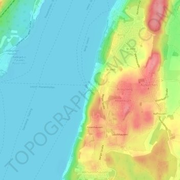
Nom : Carte topographique Leoni, altitude, relief.
Lieu : Leoni, Berg, Landkreis Starnberg, Bavaria, 82335, Germany (47.93479 11.32425 47.97479 11.36425)
Altitude moyenne : 616 m
Altitude minimum : 581 m
Altitude maximum : 688 m
Autres cartes topographiques
Cliquez sur une carte pour visualiser sa topographie, son altitude et son relief.
Tutzing
Germany > Bavaria > Landkreis Starnberg
Tutzing, Landkreis Starnberg, Bavaria, 82327, Germany
Altitude moyenne : 632 m
Mühlfeld
Germany > Bavaria > Landkreis Starnberg > Herrsching am Ammersee
Mühlfeld, Herrsching am Ammersee, Wörthsee, Landkreis Starnberg, Bavaria, 82237, Germany
Altitude moyenne : 581 m
Söcking
Germany > Bavaria > Landkreis Starnberg > Starnberg
Söcking, Starnberg, Wörthsee, Landkreis Starnberg, Bavaria, 82237, Germany
Altitude moyenne : 651 m
Starnberg
Germany > Bavaria > Landkreis Starnberg
Starnberg, Landkreis Starnberg, Bavaria, 82319, Germany
Altitude moyenne : 631 m
Weßling
Germany > Bavaria > Landkreis Starnberg
Weßling, Landkreis Starnberg, Bavaria, 82234, Germany
Altitude moyenne : 591 m