
Carte topographique Davison Street
Carte interactive
Cliquez sur la carte pour afficher l’altitude.
À propos de cette carte
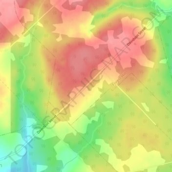
Nom : Carte topographique Davison Street, altitude, relief.
Altitude moyenne : 195 m
Altitude minimum : 142 m
Altitude maximum : 229 m
Autres cartes topographiques
Cliquez sur une carte pour visualiser sa topographie, son altitude et son relief.
Gaspereau Mountain
Canada > Nova Scotia > Municipality of the County of Kings > Forest Hill
Gaspereau Mountain, Forest Hill, Municipality of the County of Kings, Kings County, Nova Scotia, B4P 2R1, Canada
Altitude moyenne : 185 m